What are RCOFs and their purpose?
In the late 1990s, an innovative process known as the Regional Climate Outlook Forum (RCOF) was initiated by WMO, National Meteorological and Hydrological Services (NMHSs), regional institutions, and other international organizations. It is a forum that brings together the experts from a climatologically homogeneous region and provides consensus based, climate prediction and information usually for the season having critical socio-economic significance. This information has been applied to reducing climate-related risks and supporting sustainable development. Such forums have spread to many regions across the world.
These forums bring together national, regional and international climate experts, on an operational basis, to produce regional climate outlooks based on input from NMHSs, regional institutions, Regional Climate Centres (RCCs) and global producers of climate predictions. By bringing together countries having common climatological characteristics, the forums ensure consistency in the access to and interpretation of climate information. Through interaction with sectoral users, extension agencies and policy makers, RCOFs assess the likely implications of the outlooks on the most pertinent socio-economic sectors in the given region and explore the ways in which these outlooks could be made use of.
The core concept of all the RCOFs remains the same: delivering consensus based user-relevant climate outlook products in real-time through regional cooperation and partnership. However, since national and regional capacities are varied and, in some cases, are inadequate to face the task individually, the implementation mechanisms of the RCOFs in different regions have been tailored to meet the local conditions.
(see more at https://www.wmo.int/pages/prog/wcp/wcasp/documents/RCOFsBrochure.pdf )
What is MedCOF?
Launched following the Scoping Meeting in June 2013 at the State Meteorological Agency of Spain, the Mediterranean Climate Outlook Forum (MedCOF) generates consensus seasonal forecasts for the Mediterranean region and Northern African region. The forum reflects the World Meteorological Organization’s (WMO) desire to increase the availability of user-friendly climate service. Its purpose is to improve climate scientists' understanding of the information needs of different user groups and thus able to produce more usable and salient climate information. The aim of MedCOF is to strengthen the collaboration between the Regional Associations I and VI in developing capacities for the Climate Services Information System within the Global Framework for Climate Services (GFCS). MedCOF brings together all the member countries of the South-Eastern Europe Climate Outlook Forum (SEECOF) and those of the forum of Prévisions Climatiques Saisonnières en Afrique du Nord (PRESANORD) and France, Italy, Jordan, Lebanon, Malta, Mauritania, Portugal, Spain and Syria.
The first forum was conducted in November 2013 by the Republic Hydro-meteorological Service of Serbia in Belgrade. The forum is conducted twice per year through teleconference in May-June and in an assembly in November.
The forum stands for an opportunity to member countries to exchange information on the last and current knowledge of climate conditions. Besides, it promotes training and operational activities on seasonal timescales.
Why do we need an RCOF specifically for the Mediterranean region?
The Mediterranean region is characterized by a complex morphology, due to the presence of many sharp orographic features; high mountain ridges surround the Mediterranean Sea on almost every side, presence of distinct basins and gulfs, islands and peninsulas of various sizes. These characteristics have important consequences on both sea and atmospheric circulation, because they determine a large spatial variability and the presence of many sub-regional and meso-scale features.
Droughts and floods are among the most dangerous meteorological hazards affecting the Mediterranean countries followed by windstorms and hail. Floods affect the entire Mediterranean region but their frequencies and impacts are not homogeneous over the entire area. The demographic contrasts (with high population densities in the Eastern Spain, Southern France, Italy, the West of the Balkan Peninsula and Egypt) and the large economic and cultural differences make these regions highly vulnerable and prone to significant economic losses. Water management, agriculture, energy, tourism, energy and both production and demand are a major stake for a number of Mediterranean countries.
To cope with such specific geographical and climatic features of the Mediterranean region and to strengthen the collaboration between the Regional Associations I and VI in developing capacities for the Climate Services Information System within the Global Framework for Climate Services (GFCS), it was decided to launch the Mediterranean Climate Outlook Forum (MedCOF) following the Scoping Meeting held in June 2013 at the State Meteorological Agency of Spain
Why do we need a consensus forecast?
Seasonal forecast information is highly demanded by many economic sectors affected by decisions on monthly/seasonal time frame. Many seasonal forecast providers have developed their own tools to meet this demand and deliver their own products, neglecting the importance of a coherent, consistent and agreed message under the authoritative voice of WMO. The release of non-coinciding seasonal forecasts –when not clearly contradictory- by different NMHSs belonging to the same climatologically homogeneous region is very damaging for the credit of the institutions issuing such forecasts and convey a negative message on the lack of usefulness of forecasts at such time scales. One single and agreed by consensus voice based on all available information is definitely much better than a dissonant chorus delivering a multiplicity of messages.
What is the Global Framework for Climate Services (GFCS)?
The World Meteorological Organization- (WMO) sponsored World Climate Conference-3 (WCC3) and the resulting Global Framework for Climate Services (GFCS) have expressed in clear terms the increasing need for robust climate information covering future periods ranging from several months up to several years for economic, industrial and political planning. The GFCS has created a conceptual structure to close the gap in the provision of climate information and services between the information producers and its users, the latter ranging from policy-makers to the industry. The WMO-designated Global Producing Centres (GPCs) for long-range predictions are a key piece in this structure, where the GPCs feed the Regional Climate Centres (RCCs) and the National Meteorological and Hydrological Services (NMHSs) with the best climate information possible. Climate predictions produced by all designated GPCs are collected operationally by WMO’s Lead Centre for Long-Range Forecasts (LC-LRFMME). This structure brings together prediction generators and local to regional focal points like the Regional Climate Outlook Fora (RCOF), NMHSs and private partners via, for instance, the LC-LRFMME to facilitate the development of consensus-based seasonal predictions with socio-economic potential.
What are Seasonal Forecasts?
Contrary to deterministic day-to-day forecasts, seasonal forecasts refer to the climate –i.e., departures from the average- for the coming seasons. They are probabilistic in nature and always relative to a mean climate.
What is a probabilistic forecast?
A probabilistic forecast describes the “chance” of something happening, like a coin toss that has a 50% chance of heads and a 50% chance of tails or a dice throwing where the probability of getting one particular value is 1/6. This is different from a deterministic forecast, which predicts only one specific number or outcome (choosing only heads OR tails in a coin toss).
How can we do seasonal predictions if we can’t even predict the weather next week?
Predicting how climate will be in the next season is a different scientific issue from predicting weather a few weeks from now. Weather is short term and chaotic, largely determined by whatever atmospheric system is moving through at the time, and thus it is increasingly difficult to predict day-to-day changes beyond about two weeks into the future. Seasonal predictions, on the other hand, are a statistical average of weather and are determined by larger-scale drivers, such as variability patterns like El Niño, or variables carrying long-term memory like sea-surface temperature, or external drivers like powerful volcanic eruptions.
What factors are limiting our ability to improve seasonal predictions?
Model errors and forecast initialization are the main limiting factors of seasonal forecast quality, and the predictability limit has not been reached. While multi-model techniques improve forecast quality, they are still far from being applied to their full potential. There may be untapped predictability due to interactions between the components of the total climate system that are not fully accounted for in seasonal models.
What is the difference between quality and value of seasonal prediction?
Quality refers to the technical measurement of forecast performance; quality is of prime concern to scientists and is often pertinent for users. Value relates to the practical benefits achieved through decision-making based on forecast information, usually in conjunction with other information, and, while of fundamental concern to the user, should also stimulate seasonal prediction scientists.
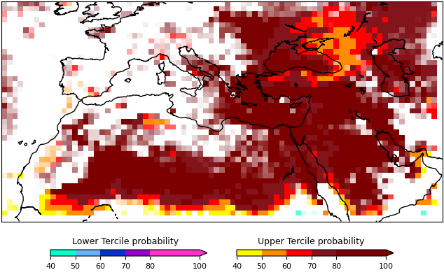
What are the “windows of opportunity” for seasonal forecasts?
Windows of opportunity are periods of higher positive skill when a forecasting system performs particularly well. A typical example of window of opportunity is the forecasts produced while an El Niño event is underway. Numerical models are beginning to represent the links between tropical phenomena and modes of variability affecting mid-latitudes. The identification of windows of opportunity with increased forecast skill could be the basis for enhanced, actionable forecasts. However, much more research is needed to explore all the potential sources of predictability and model development is needed to subsequently exploit this potential predictability. An example of windows of opportunity for the Mediterranean region is the seasonal forecast of temperature for the summer period for most of the state-of-the-art seasonal models.
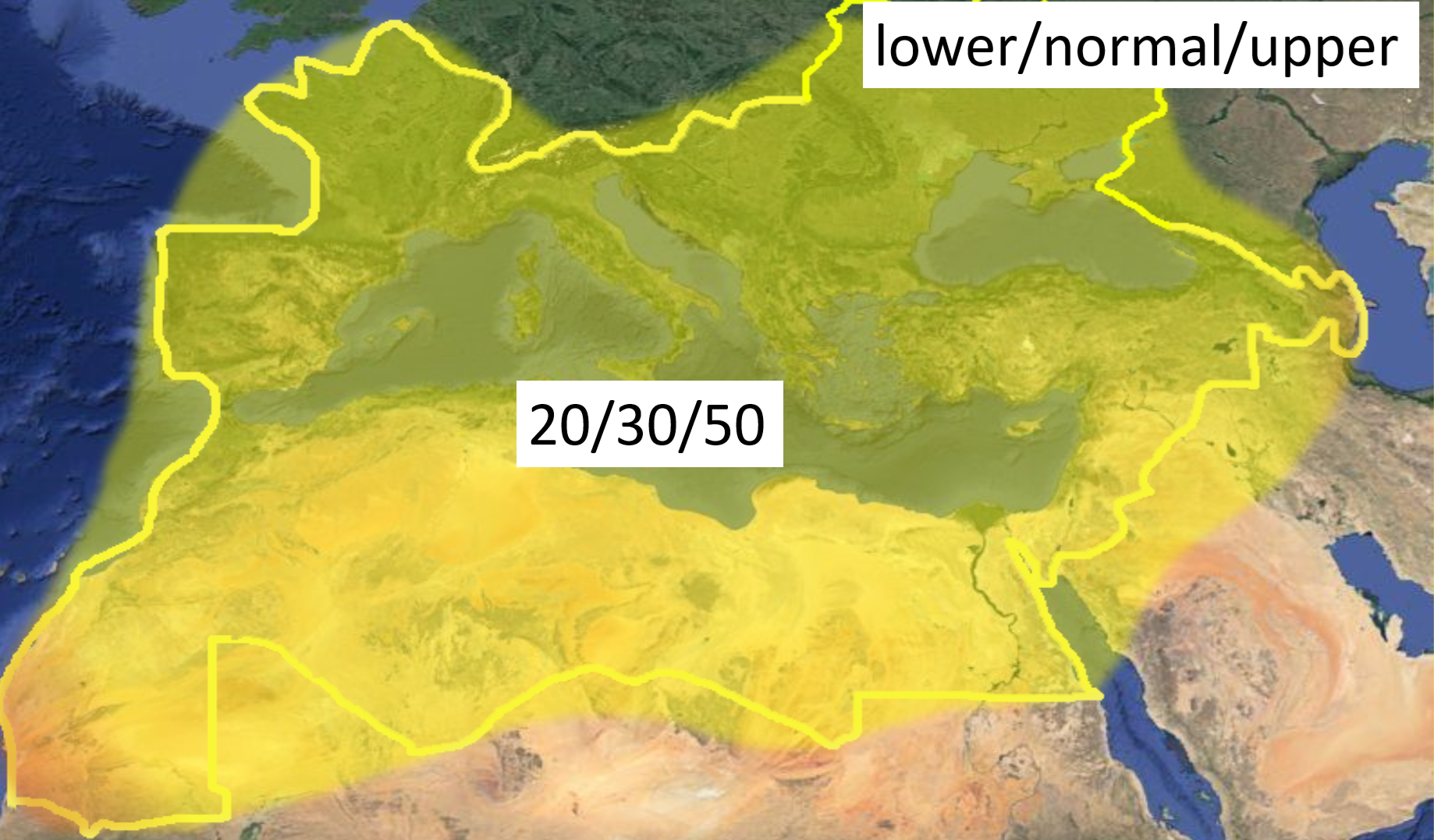
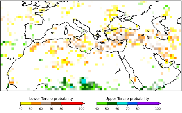
What are terciles?
Terciles are defined by arranging the historical data (e.g. precipitation or temperature) in ascending order (lowest to highest) and then partitioning the data into three equal sized groups, for example if there were 120 years of record each group would contain 40 years. The lower third of the data values are defined as the lower tercile, the middle third of the values are the middle tercile and the upper third of the values are the upper tercile. To fully define the terciles, all that is really necessary are two boundaries: the borderline between the upper and the middle tercile, and the borderline between the middle and the lower tercile. The upper limit of the upper tercile and the lower limit of the lower tercile are not necessary, because amounts higher than the highest observation or lower than the lowest observation would still be placed into the upper or the lower tercile, respectively.
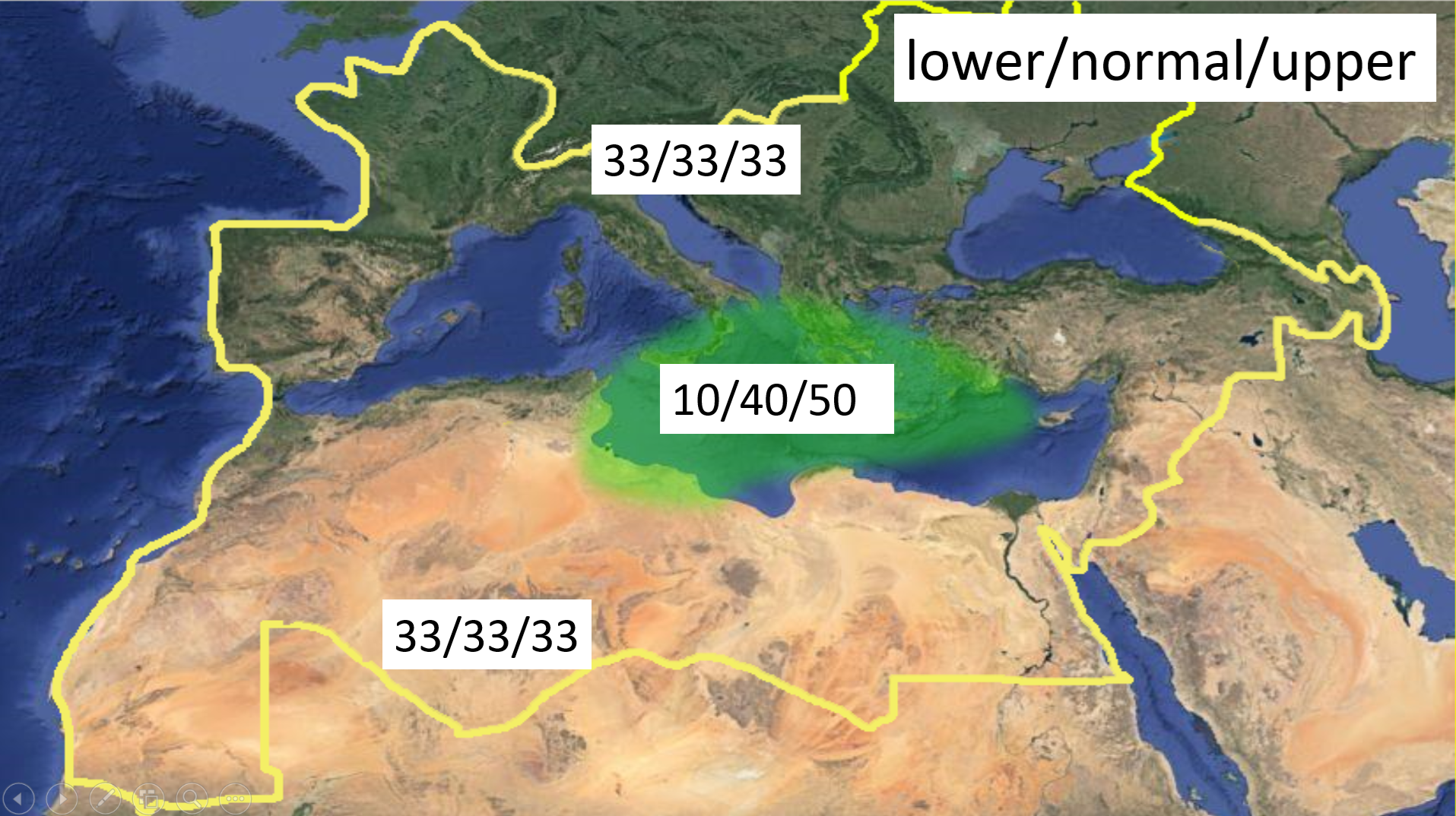
How to interpret tercile seasonal forecasts?
Terciles are defined by arranging the historical data in ascending order (lowest to highest) and then partitioning the data into three equal sized groups, for example if there were 60 years of record each group would contain 20 years. The lower third of the data values are defined as the lower tercile, the middle third of the values are the middle tercile and the upper third of the values are the upper tercile. For example, if you had 100 data values the lower tercile would contain the 1st-33rd data values, the middle tercile the 34th-67th values and the upper tercile the 68th-100th values. The values that partition the historical data into terciles are applied to the forecasted distribution. The percentage of the forecast that is in each tercile indicates the likelihood that temperature or precipitation for the next 3 months will fall within each of these tercile ranges.
Why is ENSO important for seasonal forecasts?
An important source of seasonal predictability comes from the El Niño-Southern Oscillation (ENSO), a quasi-regular variation in the atmosphere and ocean in the tropical eastern Pacific. ENSO anomalies in the Pacific are linked to anomalies in temperature and precipitation across the globe. ENSO has dominant influence and explains the Earth’s interannual climate variability.
What is predictability?
The extent to which future states of a system may be predicted based on knowledge of current and past states of the system. Since knowledge of the climate system’s past and current states is generally imperfect, as are the models that utilise this knowledge to produce a climate prediction, and since the climate system is inherently nonlinear and chaotic, predictability of the climate system is inherently limited. Even with arbitrarily accurate models and observations, there may still be limits to the predictability of such a nonlinear system (AMS, 2000).
What is the skill of a seasonal forecast?
The skill measures the success of a prediction against observationally-based information. No single measure can summarize all aspects of forecast quality and a suite of metrics is considered. Metrics will differ for forecasts given in deterministic and probabilistic form.
Do seasonal forecasts possess intrinsic value?
No. They acquire value through their ability to influence the decisions made by users of the forecasts (Murphy 1993).